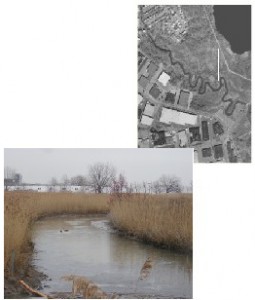
Category: Waterbodies & Other Wetlands 
Location: Located in the northeastern portion of the HMD, running along Losen Slote Creek Park, Mehrhof Pond, and the northern tip of the Empire Tract. The creek begins outside of the HMD in Little Ferry, and runs along the border of Little Ferry and Moonachie, then along the border of Little Ferry and South Hackensack, before it outlets into the Hackensack River in Bergen County.
Current Land Use: Open Water
Site Description: Losen Slote Creek (also known as Eckles Creek) is not influenced by tidal waters due to a tide gate located near its outlet into the Hackensack River. The tide gate was installed by the Bergen County Mosquito Commission, sometime around 1921. The creek receives freshwater inputs from surrounding areas. There are freshwater meadows and forested wetlands located along the banks.
Existing Site-Specific Data Inventory
A. Survey, Maps, and GIS
HMD regional data exists inclusive of this site.
B. Real Estate/Ownership
N/A
C. Site History & Land Use
No data obtained.
D. Biological Studies – Fauna
No data obtained.
E. Biological Studies – General Environmental
No data obtained.
F. Geotechnical
No data obtained.
G. Hydraulics and Hydrology
No data obtained.
H. Water and Sediments
Chemistry and water quality data collected in 1971.
I. Historical/Cultural Resources
No data obtained.
J. Restoration/Remediation Design Plans
No data obtained.
Site Reports
Site #37 – Losen Slote Creek
Category: Waterbodies & Other Wetlands
Location: Located in the northeastern portion of the HMD, running along Losen Slote Creek Park, Mehrhof Pond, and the northern tip of the Empire Tract. The creek begins outside of the HMD in Little Ferry, and runs along the border of Little Ferry and Moonachie, then along the border of Little Ferry and South Hackensack, before it outlets into the Hackensack River in Bergen County.
Current Land Use: Open Water
Site Description: Losen Slote Creek (also know as Eckles Creek) is not influenced by tidal waters due to a tide gate located near its outlet into the Hackensack River. The tide gate was installed by the Bergen County Mosquito Commission, sometime around 1921. The creek receives freshwater inputs from surrounding areas. There are freshwater meadows and forested wetlands located along the banks.
Existing Site Specific Data Inventory
* – Report repeated under multiple data categories and/or sites.
A. Survey, Maps, and GIS
Relevant survey, mapping, and GIS data for the Meadowlands can be found in the Meadowlands-wide site report under data category A.
B. Real Estate/Ownership
Not applicable.
C. Site History & Land Use
No data obtained.
D. Biological Studies – Fauna
No data obtained.
E. Biological Studies – General Environmental
No data obtained.
F. Geotechnical
No data obtained.
G. Hydraulics and Hydrology
No data obtained.
H. Water and Sediments
1. *Mattson, C., G. Potera, & M.E. Saks. Water Quality in a Disordered Ecosystem: A Report on the Water Quality Monitoring Study Performed in the Hackensack Meadowlands between June and September 1971. 1971. [1a] Part of a natural resource inventory on which to base future land use decisions and against which to make future comparisons. Chemistry and water quality were measured at 11 sites, including Berry’s Creek, Penhorn Creek, Losen Slote Creek, Bellman’s Creek, Moonachie Creek, Mill Creek, and the Hackensack River.
I. Historical/Cultural Resources
No data obtained.
J. Restoration/Remediation Design Plans
No data obtained.
K. Bibliographic Updates
Site #37: Losen Slote Creek
