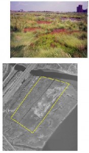
Category: Existing Restoration/Preservation, and/or Mitigation Site 
Location: Bordered on the west by the New Jersey Turnpike -Western Spur, on the east by Lyndhurst Riverside Marsh and the Hackensack River, and to the north by Berry’s Creek in Lyndhurst, Bergen County.
Latitude/Longitude: 40.78553/-74.08970
Current Land Use: Tidal marsh
Size: 21 acres
Current Ownership: NJMC
Site Description: The Bellemead Mitigation site was restored in the 1990’s and includes two marsh areas separated by a ditch that runs from Mary Ann Creek to Berry’s Creek. Prior to restoration, the sites were both undeveloped and supported a monoculture of common reed (Phragmites australis). The low marsh area (approximately seven acres in size) is located west of the tributary and is dominated by smooth cordgrass (Spartina alterniflora). The low marsh area was created in approximately 1993 through the excavation of previously placed dredged material. The site was graded with a two percent slope and then planted with S. alterniflora. The high marsh area, created in approximately 1996, was mowed and replanted with saltmarsh hay (Spartina patens). Currently the low marsh site continues to be dominated by S. alterniflora with inclusions of Phragmites. The high marsh area is dominated by Phragmites and spikegrass (Distichlis spicata),with inclusions of S. patens, tall cordgrass (Spartina cynosuroides), S. alterniflora, and Salicornia species
Existing Site-Specific Data Inventory
A. Survey, Maps, and GIS
HMD regional data exists inclusive of this site.
B. Real Estate/Ownership
Owned by NJMC
C. Site History & Land Use
No data obtained.
D. Biological Studies – Fauna
General baseline data collected in 1988 for NJ Turnpike Widening EIS.
E. Biological Studies – General Environmental
Site-specific wetland functional analysis conducted in 1992. General baseline data collected in 1988 for NJ Turnpike Widening EIS.
F. Geotechnical
General baseline data collected in 1988 for NJ Turnpike Widening EIS.
G. Hydraulics and Hydrology
General baseline data collected in 1988 for NJ Turnpike Widening EIS.
H. Water and Sediments
General baseline data collected in 1988 for NJ Turnpike Widening EIS.
I. Historical/Cultural Resources
No data obtained.
J. Restoration/Remediation Design Plans
Open brackish marsh conceptual restoration plan developed in 1987.
Site Reports
Site #1 – Bellemead Mitigation
Category: Existing Restoration, Preservation, and/or Mitigation Site
Location: Bordered on the west by the New Jersey Turnpike – Western Spur, on the east by Lyndhurst Riverside Marsh and the Hackensack River, and to the north by Berry’s Creek in Lyndhurst, Bergen County.
Latitude/Longitude: 40.78553 / -74.08970
Current Land Use: Tidal marsh
Size: 21 acres
Current Ownership: NJMC
Site Description: The Bellemead Mitigation site was restored in the 1990’s and includes two marsh areas separated by a ditch that runs from Mary Ann Creek to Berry’s Creek. Prior to restoration, the sites were both undeveloped and supported a monoculture of common reed (Phragmites australis). The low marsh area (approximately seven acres in size) is located west of the tributary and is dominated by smooth cordgrass (Spartina alterniflora). The low marsh area was created in approximately 1993 through the excavation of previously placed dredged material. The site was graded with a two percent slope and then planted with S. alterniflora. The high marsh area, created in approximately 1996, was mowed and replanted with saltmarsh hay (Spartina patens). Currently the low marsh site continues to be dominated by S. alterniflora with inclusions of Phragmites. The high marsh area is dominated by Phragmites and spikegrass (Distichlis spicata), with inclusions of S. patens, tall cordgrass (Spartina cynosuroides), S. alterniflora, and Salicornia species.
Existing Site Specific Data Inventory
* – Report repeated under multiple data categories and/or sites.
A. Survey, Maps, and GIS
Relevant survey, mapping, and GIS data for the Meadowlands can be found in the Meadowlands-wide site report under data category A.
B. Real Estate/Ownership
NJMC acquired the Bellmead Mitigation site on April 29, 1999.
C. Site History & Land Use
No data obtained.
D. Biological Studies – Fauna
- *U.S. Coast Guard & USACE. Draft Environmental Impact Statement and Section 404 (b)(1) Evaluation – New Jersey Turnpike Widening Project: Interchange 11 to U.S. Route 46. New Jersey Turnpike Authority. 1988. [1a]States project purpose and need, alternatives, affected environment, and environmental consequences.
E. Biological Studies – General Environmental
- Environmental Concern, Inc. A Quantitative Comparison of the Proposed Wetland Mitigation Site and Impacted Site (C & F Realty, Ltd./Berry Creek Distribution Center). April 1992. [4] Evaluates the wetland functions lost through impacts at the Berry Creek Distribution Center Development Site in Carlstadt, NJ and compares them to the functions that will be gained from the proposed mitigation project located in Lyndhurst, NJ. Three approaches were used: HEP, WET, and literature validation.
- *U.S. Coast Guard & USACE. Draft Environmental Impact Statement and Section 404 (b)(1) Evaluation – New Jersey Turnpike Widening Project: Interchange 11 to U.S. Route 46. New Jersey Turnpike Authority. 1988. [1a]States project purpose and need, alternatives, affected environment, and environmental consequences.
F. Geotechnical
- *U.S. Coast Guard & USACE. Draft Environmental Impact Statement and Section 404 (b)(1) Evaluation – New Jersey Turnpike Widening Project: Interchange 11 to U.S. Route 46. New Jersey Turnpike Authority. 1988. [1a]States project purpose and need, alternatives, affected environment, and environmental consequences.
G. Hydraulics and Hydrology
- *U.S. Coast Guard & USACE. Draft Environmental Impact Statement and Section 404 (b)(1) Evaluation – New Jersey Turnpike Widening Project: Interchange 11 to U.S. Route 46. New Jersey Turnpike Authority. 1988. [1a]States project purpose and need, alternatives, affected environment, and environmental consequences.
H. Water and Sediments
- *U.S. Coast Guard & USACE. Draft Environmental Impact Statement and Section 404 (b)(1) Evaluation – New Jersey Turnpike Widening Project: Interchange 11 to U.S. Route 46. New Jersey Turnpike Authority. 1988. [1a]States project purpose and need, alternatives, affected environment, and environmental consequences.
I. Historical/Cultural Resources
No data obtained.
J. Restoration/Remediation Design Plans
- TAMS Consultants, Inc. Revised Bellemead Brackish Wetland Mitigation Plan. June 1987. [1a]Details the open brackish marsh concept for the Bellemead site and contains specific engineering and horticultural plans to implement the concept.
K. Bibliographic Updates
Site #1: Bellemead Mitigation
