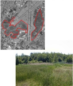
Category: Candidate Restoration/Preservation Site 
Location: The site is bordered by Moonachie Avenue to the south and New Jersey Transit Pascack Valley Line in Moonachie, Teterboro, and Little Ferry, Bergen County
Latitude/Longitude: 40.84622/-74.05548
Current Land Use: Freshwater wetland
Size: 258 acres
Current Ownership: Port Authority of New York and New Jersey
Site Description: The Teterboro Woods site consists of two separate areas southeast and southwest of the Teterboro Airport. The dominant wetland type is palustrine, successional broad-leaved deciduous forested/scrub-shrub with pockets of emergent wetlands. Upland inclusions and some disturbed areas are scattered among the wetland areas. Disturbance is mostly due to excavation and subsequent filling, as well as ditch dredging and spoil disposal. The Teterboro Woods site is slated for preservation.
Existing Site-Specific Data Inventory
A. Survey, Maps, and GIS
HMD regional data exists inclusive of this site. A topographic survey is included in the 1999 wetland delineation report.
B. Real Estate/Ownership
Owned by Port Authority of New York and New Jersey.
C. Site History & Land Use
No data obtained.
D. Biological Studies – Fauna
No data obtained.
E. Biological Studies – General Environmental
Wetland delineations conducted in 1987 and 1999. Wetland quality assessment conducted in 1999. A JD was issued in 2001.
F. Geotechnical
Soils information was collected during a 1987 wetland delineation.
G. Hydraulics and Hydrology
No data obtained.
H. Water and Sediments
No data obtained.
I. Historical/Cultural Resources
No data obtained.
J. Restoration/Remediation Design Plans
Conceptual design developed to mitigate for unauthorized fill at Teterboro Airport in 1987.
Site Reports
Site #30 – Teterboro Woods
Category: Candidate Restoration/Preservation Site
Location: The site is bordered by Moonachie Avenue to the south and New Jersey Transit Pascack Valley Line in Moonachie, Teterboro, and Little Ferry, Bergen County
Latitude/Longitude: 40.84622 / -74.05548
Current Land Use: Freshwater wetland
Size: 258 acres
Current Ownership: Port Authority of New York and New Jersey
Site Description: The Teterboro Woods site consists of two separate areas southeast and southwest of the Teterboro Airport. The dominant wetland type is palustrine, successional broad-leaved deciduous forested/scrub-shrub with pockets of emergent wetlands. Upland inclusions and some disturbed areas are scattered among the wetland areas. Disturbance is mostly due to excavation and subsequent filling, as well as ditch dredging and spoil disposal. The Teterboro Woods site is slated for preservation.
Existing Site Specific Data Inventory
* – Report repeated under multiple data categories and/or sites.
A. Survey, Maps, and GIS
Relevant survey, mapping, and GIS data for the Meadowlands can be found in the Meadowlands-wide site report under data category A.
1. *The Louis Berger Group, Inc. Teterboro Airport: Final Wetland Delineation Report. December 1999. [6] A wetland delineation was performed to determine the extent of federal and/or state jurisdictional boundaries, as well as identify and characterize types, of all wetlands and open water bodies within the project area. Several different wetland classes were identified and a total of 68 wetland areas were delineated. The delineated wetland boundaries were overlaid on a 1-foot contour topographic map provided by the Port Authority of New York and New Jersey (the property owner).
B. Real Estate/Ownership
Teterboro Woods is owned by the Port Authority of New York and New Jersey.
C. Site History & Land Use
No data obtained.
D. Biological Studies – Fauna
No data obtained.
E. Biological Studies – General Environmental
2. Louis Berger & Associates, Inc. Report on Environmental Conditions at Teterboro Airport. May 1989. [1a]Details the wetlands and stream encroachment in the vicinity of the East and West Riser Ditches at Teterboro Airport.
3. Louis Berger and Associates, Inc. Wetland Delineation Report for Teterboro Airport. May 1987. [6] A field survey of the Teterboro Airport was conducted during the winter and spring months of 1986 and 1987. This report includes detailed wetland and upland descriptions, a soil log, and recommendations for fill operations at the airport site.
4. Louis Berger & Associates, Inc. Wetland Mitigation for Teterboro Airport. 1987 [1a]Details a wetland delineation and unauthorized wetland fill determination for the South Development and East Areas. Includes applications for USACE Section 404 and NYSDEC Stream Encroachment permits Includes concepts to mitigation for unauthorized fill.
5. *The Louis Berger Group, Inc. Teterboro Airport: Final Wetland Delineation Report. December 1999. [6] A wetland delineation was performed to determine the extent of federal and/or state jurisdictional boundaries, as well as identify and characterize types, of all wetlands and open water bodies within the project area. Several different wetland classes were identified and a total of 68 wetland areas were delineated. The delineated wetland boundaries were overlaid on a 1-foot contour topographic map provided by the Port Authority of New York and New Jersey (the property owner).
6. USACE. Jurisdictional Determination: Teterboro Woods/Airport Site (App. No. 2000-01158). 10/3/2001. [2] A jurisdictional determination was performed by the USACE in 2001 for the Teterboro Woods/Airport Site.
F. Geotechnical
7. Louis Berger and Associates, Inc. Wetland Delineation Report for Teterboro Airport. May 1987. [6] A field survey of the Teterboro Airport was conducted (following the 1987 Corps of Engineers Wetland Delineation Manual) during the winter and spring months of 1986 and 1987. This report includes detailed wetland and upland descriptions, a soil log, and recommendations for fill operations at the airport site.
G. Hydraulics and Hydrology
No data obtained.
H. Water and Sediments
No data obtained.
I. Historical/Cultural Resources
No data obtained.
J. Restoration/Remediation Design Plans
8. Louis Berger & Associates, Inc. Wetland Mitigation for Teterboro Airport. 1987 [1a]Details a wetland delineation and unauthorized wetland fill determination for the South Development and East Areas. Includes applications for USACE Section 404 and NYSDEC Stream Encroachment permits Includes concepts to mitigate for unauthorized fill.
K. Bibliographic Updates
Site #30: Teterboro Woods
