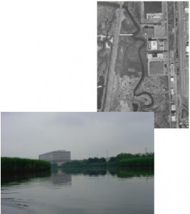
Category: Waterbodies & Other Wetlands 
Location: Located to the east of the Hackensack River, flowing through the Mori Tract and Eastern Brackish Marsh, under the New Jersey Turnpike – Eastern Spur, and along the northern boundary of Western Brackish Marsh. The creek begins in Secaucus and flows along the border between Secaucus and North Bergen out to the Hackensack River in Hudson County.
Current Land Use: Open Water
Site Description: Cromakill Creek is tidally influenced. An active sewage treatment plant discharges effluent into its upper reaches, causing poor water quality throughout the year. Heavy sedimentation, presumably from the effluent, and common reed (Phragmites australis) invasion are choking off the creek channel.
Existing Site-Specific Data Inventory
A. Survey, Maps, and GIS
HMD data exists inclusive of this site.
B. Real Estate/Ownership
N/A
C. Site History & Land Use
Ecological management plan for the HMD from 1978 includes general land use planning information.
D. Biological Studies – Fauna
No data obtained.
E. Biological Studies – General Environmental
Ecological report conducted for effects of the Kearny Generating Station on various waterways within the Hackensack Estuary in 1988.
F. Geotechnical
No data obtained.
G. Hydraulics and Hydrology
No data obtained.
H. Water and Sediments
Water quality studies conducted in 1978, 1980, and 1994. Water and sediment quality investigation conducted in 2001.
I. Historical/Cultural Resources
No data obtained.
J. Restoration/Remediation Design Plans
No data obtained.
Site Reports
Site #33 – Cromakill Creek
Category: Waterbodies & Other Wetlands
Location: Located to the east of the Hackensack River, flowing through the Mori Tract and Eastern Brackish Marsh, under the New Jersey Turnpike – Eastern Spur, and along the northern boundary of Western Brackish Marsh. The creek begins in Secaucus and flows along the border between Secaucus and North Bergen out to the Hackensack River in Hudson County.
Current Land Use: Open Water
Site Description: Cromakill Creek is tidally influenced. An active sewage treatment plant discharges effluent into its upper reaches, causing poor water quality throughout the year. Heavy sedimentation, presumably from the effluent, and common reed (Phragmites australis) invasion are choking off the creek channel.
Existing Site Specific Data Inventory
* – Report repeated under multiple data categories and/or sites.
A. Survey, Maps, and GIS
Relevant survey, mapping, and GIS data for the Meadowlands can be found in the Meadowlands-wide site report under data category A.
B. Real Estate/Ownership
Not applicable.
C. Site History & Land Use
1. *Mattson, C. P. Ecological and Resource Management Plan for the Hackensack Meadowlands. 1978. [1a]A synopsis of what the then eight-year-old HMDC had learned about the Hackensack Estuary. Section 1 is an ecological primer, Section 2 provides information on the state of the estuary, and Section 3 presents natural resource management strategies for wetlands, water quality, open space, and land use planning.
D. Biological Studies – Fauna
No data obtained.
E. Biological Studies – General Environmental
2. *EA Science and Technology & PSE&G. Kearny Generating Station Supplemental 316(b) Report. NJDEP. 1988. [1a] Evaluates the effects of the cooling water intake of the Kearny Generating Station on the ecology of the Hackensack River and adjacent waters, based on entrainment and impingement data collected from June 1987 to April 1988, and on biological data collected from the vicinity of the Kearny station since August 1986. Studies of macrozooplankton, ichthyoplankton, and juvenile and adult fish were conducted in vicinity of the station and the full length of the estuary. Includes background information on the Hackensack Estuary.
F. Geotechnical
No data obtained.
G. Hydraulics and Hydrology
No data obtained.
H. Water and Sediments
3. *Anonymous (HMDC). Biological Water Quality and Field Sampling Survey of the Hackensack Meadowlands. 1980. [1a]During a one-day sampling event, water quality was measured at 11 sites for temperature, salinity, DO, and TSS. Also set fish sampling nets in Berry’s Creek Canal and Sawmill Creek.
4. Engineering & Environmental Services, Inc. Surface Water & Sediment Quality Investigation Block 227, Lot 1, Town of Secaucus, Hudson County, New Jersey. January 2001. [2] Submitted as part of an existing Jurisdictional Determination. It contains excerpts from the January 2001 Report relative to sampling location and existing water and sediment quality within Cromakill Creek.
5. *Konsevick, Edward, Christine Cheng Hobble, & Paul Lupini. Monitoring Effects of Urban Land Use of Esturine Water Quality, Hackensack Meadowlands District, New Jersey. November 1994. [1] In 1993, the USGS, in cooperation with the HMDC, established a network of 14 ambient water monitoring sites, including the Hackensack River, Berry’s Creek, Penhorn Creek, Sawmill Creek, Mill Creek, and Cromakill Creek, to characterize the current status of water quality in the HMD. Salinity, DO, fecal coliform, pH, TSS, turbidity, total phosphorous, ammonia, sulfate, BOD, COD, heavy metal concentrations were measured at each of the monitoring sites.
6. *Mattson, C. P. Ecological and Resource Management Plan for the Hackensack Meadowlands. 1978. [1a]A synopsis of what the then eight-year-old HMDC had learned about the Hackensack Estuary. Section 1 is an ecological primer, Section 2 provides information on the state of the estuary, and Section 3 presents natural resource management strategies for wetlands, water quality, open space, and land use planning.
I. Historical/Cultural Resources
No data obtained.
J. Restoration/Remediation Design Plans
No data obtained.
K. Bibliographic Updates
Site #33: Cromakill Creek
