Category: Candidate Restoration/Preservation Site
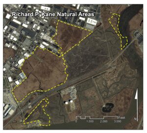
Location: Bordered on the east by the Hackensack River and on the south by the New Jersey Turnpike – Western Spur, in Carlstadt, Bergen County.
Latitude/Longitude: 40.82147/-74.05017
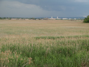
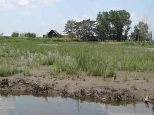
Current Land Use: Tidal and non-tidal marsh
Size: 587 acres
Current Ownership: Meadowlands Conservation Trust
Site Description: Prior to 2007, all but a 21 acre parcel of the 587 acre Richard P. Kane Natural Areas was cut off from tidal inundation due to earthen dikes and tide gates built along the Hackensack River by the Bergen County Mosquito Commission in the 1920’s and 1930’s. Repeated dike breaches and tide gate failures in 2007, 2008 and 2009 allowed sporadic tidal inundation into what had, since the 1930’s, developed into a non-tidal freshwater common reed (Phragmites australis) dominated wetland. In June 2010, tidal flow was once again excluded from the two large parcels of the Richard P. Kane Natural Areas (totaling 285 acres) that sit upstream of the NJ Turnpike by the construction of new tide gates on the culverts that convey Bashes and Moonachie Creeks underneath the NJ Turnpike’s Western Spur. Also during 2010, the northernmost 19.85 acre portion of the Richard P. Kane Natural Areas was restored as a stand-alone freshwater wetland mitigation site. With the completion of construction and planting of Spartina alterniflora at the Richard P. Kane tidal wetland mitigation bank in September 2012, tidal flow was restored to a 217 acre portion of the Richard P. Kane Natural Areas that lies between Moonachie Creek and the Hackensack River (see the Site Report for the Kane Mitigation Bank in the Existing Restoration, Preservation and/or Mitigation section). The removal of the old riverfront Moonachie Creek tide gate and permanent breaching of the riverfront dike as part of the 2012 construction of the MRI Phase 3 wetland mitigation bank has returned tidal flow to the 41 acre portion of the Richard P. Kane Natural Areas now known as the Lower Kane Tract (on the Hackensack River, adjacent to River Barge Park in Carlstadt). The 21 acre parcel that lies between the Kane tidal mitigation bank and the Hackensack River, mainly in the Town of South Hackensack, remains a tidally flowed Phragmites marsh.
Existing Site-Specific Data Inventory
A. Survey, Maps, and GIS
HMD regional data exists inclusive of this site. An existing conditions map was developed for a 2002 EIS.
B. Real Estate/Ownership
Owned by the Meadowlands Conservation Trust.
C. Site History & Land Use
Site history and land use information is included in various sources, including a 2002 EIS.
D. Biological Studies – Fauna
Baseline studies and an avian survey were conducted in the late 1990’s.
E. Biological Studies – General Environmental
Various baseline data and wetland quality assessments were conducted between 1995 and 2002. A JD was completed in 1997.
F. Geotechnical
Site-specific baseline data collected for the 2002 EIS.
G. Hydraulics and Hydrology
Water budget and stormwater management study completed in 2000 and baseline data collected for 2002 EIS.
H. Water and Sediments
Water quality analysis completed in 2000 and baseline data collected for 2002 EIS
I. Historical/Cultural Resources
Baseline data collected for the 2002 EIS.
J. Restoration/Remediation Design Plans
Conceptual mitigation plans and mitigation impact assessments developed in 1998, 1999 and 2000, and also presented in 2002 EIS.
Site Reports
Site #14 – Richard P. Kane Natural Areas
Category: Candidate Restoration/Preservation Site
Location: Bordered on the east by the Hackensack River and on the south by the New Jersey Turnpike – Western Spur, in Carlstadt, Bergen County.
Latitude/Longitude: 40.82147 / -74.05017
Current Land Use: Brackish marsh
Size: 587 acres
Current Ownership: Meadowlands Conservation Trust
Site Description: Prior to 2007, all but a 21 acre parcel of the 587 acre Richard P. Kane Natural Areas was cut off from tidal inundation due to earthen dikes and tide gates built along the Hackensack River by the Bergen County Mosquito Commission in the 1920’s and 1930’s. Repeated dike breaches and tide gate failures in 2007, 2008 and 2009 allowed sporadic tidal inundation into what had, since the 1930’s, developed into a non-tidal freshwater common reed (Phragmites australis) dominated wetland. In June 2010, tidal flow was once again excluded from the two large parcels of the Richard P. Kane Natural Areas (totaling 285 acres) that sit upstream of the NJ Turnpike by the construction of new tide gates on the culverts that convey Bashes and Moonachie Creeks underneath the NJ Turnpike’s Western Spur. Also during 2010, the northernmost 19.85 acre portion of the Richard P. Kane Natural Areas was restored as a stand-alone freshwater wetland mitigation site. With the completion of construction and planting of Spartina alterniflora at the Richard P. Kane tidal wetland mitigation bank in September 2012, tidal flow was restored to a 217 acre portion of the Richard P. Kane Natural Areas that lies between Moonachie Creek and the Hackensack River (see the Site Report for the Kane Mitigation Bank in the Existing Restoration, Preservation and/or Mitigation section). The removal of the old riverfront Moonachie Creek tide gate and permanent breaching of the riverfront dike as part of the 2012 construction of the MRI Phase 3 wetland mitigation bank has returned tidal flow to the 41 acre portion of the Richard P. Kane Natural Areas now known as the Lower Kane Tract (on the Hackensack River, adjacent to River Barge Park in Carlstadt). The 21 acre parcel that lies between the Kane tidal mitigation bank and the Hackensack River, mainly in the Town of South Hackensack, remains a tidally flowed Phragmites marsh.
Existing Site Specific Data Inventory
* – Report repeated under multiple data categories and/or sites.
A. Survey, Maps, and GIS
Relevant survey, mapping, and GIS data for the Meadowlands can be found in the Meadowlands-wide site report under data category A.
1. *USACE. Final Environmental Impact Statement on the Meadowlands Mills Project Proposed by Empire Ltd. 2002. [1a] Assesses potential impacts on the Richard P. Kane Natural Areas from the proposed construction of a mall, including several different fill and mitigation alternatives. Existing wetlands were assessed using the Indicator Value Assessment method.
B. Real Estate/Ownership
Richard P. Kane Natural Areas is owned by the Meadowlands Conservation Trust.
2. *USACE. Final Environmental Impact Statement on the Meadowlands Mills Project Proposed by Empire Ltd. 2002. [1a] Assesses potential impacts on the Richard P. Kane Natural Areas from the proposed construction of a mall, including several different fill and mitigation alternatives. Existing wetlands were assessed using the Indicator Value Assessment method.
C. Site History & Land Use
3. *Paulus, Sokolowski, and Sartor, Inc. Waterfront Development Permit, Water Quality Certification, Coastal Zone Management Consistency Determination, and Stream Encroachment Permit. 1996. [1a] Multi-permit application package for the Meadowlands Mills project prepared to fulfill the application requirements for NJDEP Waterfront Development Permit, Water Quality Certification, Coastal Zone Management Consistency Determination, and Stream Encroachment permits. Contains project description and project alternatives, summarizes existing site conditions, details project compliance with coastal zone management rules, and provides project checklist for water quality and stream encroachment requirements. Also listed other relevant required permits and application status.
4. *TAMS Consultants, Inc. Meadowlands Mills Wetland Mitigation Conceptual Plan: Richard P. Kane Natural Areas, Hackensack Meadowlands, New Jersey. Empire, Ltd. 1998. [1a] Presents on site mitigation plan associated with the construction of a mall at the Richard P. Kane Natural Areas. Existing wetlands were assessed and found to be of low value. Discusses site history.
5. *USACE. Final Environmental Impact Statement on the Meadowlands Mills Project Proposed by Empire Ltd. 2002. [1a] Assesses potential impacts on the Richard P. Kane Natural Areas from the proposed construction of a mall, including several different fill and mitigation alternatives. Existing wetlands were assessed using the Indicator Value Assessment method.
D. Biological Studies – Fauna
6. Paulus, Sokoloski, and Sartor, Inc. Essential Fish Habitat Assessment of the Richard P. Kane Natural Areas and Meadowlands Mills Development. November 1999. [4] Reviewed available on-site fish surveys; concluding that the non-tidal portion of the Richard P. Kane Natural Areas does not provide essential fish habitat for managed species.
7. *Paulus, Sokolowski, and Sartor, Inc. Waterfront Development Permit, Water Quality Certification, Coastal Zone Management Consistency Determination, and Stream Encroachment Permit. 1996. [1a] Multi-permit application package for the Meadowlands Mills project prepared to fulfill the application requirements for NJDEP Waterfront Development Permit, Water Quality Certification, Coastal Zone Management Consistency Determination, and Stream Encroachment permits. Contains project description and project alternatives, summarizes existing site conditions, details project compliance with coastal zone management rules, and provides project checklist for water quality and stream encroachment requirements. Also listed other relevant required permits and application status.
8. *TAMS Consultants, Inc. Avian Survey Report: Existing Conditions, Environmental Consequences, and Mitigation Activities – Richard P. Kane Natural Areas. Revised October 29, 1998. [1] A report detailing an avian survey, conducted from 1996 to 1997, to determine the overall bird usage of the Richard P. Kane Natural Areas (through which Moonachie Creek flows). The report also includes a discussion of the potential impacts to the avian community of the affected environment that would result from development and an assessment of the proposed mitigation activities for the Meadowlands Mills wetland mitigation program and its beneficial effect on avifauna.
E. Biological Studies – General Environmental
9. *Celebrano, M. A Characterization of Sites in the Hackensack Meadowlands District Experiencing Unexplained Decline of Spartina alterniflora. HMDC. 1995. [1a] Compares soils from the Eastern Brackish Marsh, Western Brackish Marsh, Richard P. Kane Natural Areas, and Metro Media sites to determine if differing soil characteristics effect the growth of smooth cordgrass (Spartina alterniflora) seedlings in the first growing season. Soil cores from were analyzed for nutrients, metals, percent organic, grain size, acid-volatile sulfides.
10. *Paulus, Sokolowski, and Sartor, Inc. Waterfront Development Permit, Water Quality Certification, Coastal Zone Management Consistency Determination, and Stream Encroachment Permit. 1996. [1a] Multi-permit application package for the Meadowlands Mills project prepared to fulfill the application requirements for NJDEP Waterfront Development Permit, Water Quality Certification, Coastal Zone Management Consistency Determination, and Stream Encroachment permits. Contains project description and project alternatives, summarizes existing site conditions, details project compliance with coastal zone management rules, and provides project checklist for water quality and stream encroachment requirements. Also listed other relevant required permits and application status.
11. *TAMS Consultants, Inc. Meadowlands Mills Wetland Mitigation Conceptual Plan: Richard P. Kane Natural Areas, Hackensack Meadowlands, New Jersey. Empire, Ltd. 1998. [1a] Presents on site mitigation plan associated with the construction of a mall at the Richard P. Kane Natural Areas. Existing wetlands were assessed and found to be of low value. Discusses site history
12. *USACE. Final Environmental Impact Statement on the Meadowlands Mills Project Proposed by Empire Ltd. 2002. [1a] Assesses potential impacts on the Richard P. Kane Natural Areas from the proposed construction of a mall, including several different fill and mitigation alternatives. Existing wetlands were assessed using the Indicator Value Assessment method.
13. U.S. Army Corps of Engineers. Jurisdictional Determination: Richard P. Kane Natural Areas Site (App. No. 1995-07440). 11/3/1997. [2] A jurisdictional determination was performed by the USACE in 1997 for the Empire Site.
F. Geotechnical
14. *Celebrano, M. A Characterization of Sites in the Hackensack Meadowlands District Experiencing Unexplained Decline of Spartina alterniflora. HMDC. 1995. [1a] Compares soils from the Eastern Brackish Marsh, Western Brackish Marsh, Richard P. Kane Natural Areas, and Metro Media sites to determine if differing soil characteristics effect the growth of smooth cordgrass (Spartina alterniflora) seedlings in the first growing season. Soil cores from were analyzed for nutrients, metals, percent organic, grain size, acid-volatile sulfides.
15. *USACE. Final Environmental Impact Statement on the Meadowlands Mills Project Proposed by Empire Ltd. 2002. [1a] Assesses potential impacts on the Richard P. Kane Natural Areas from the proposed construction of a mall, including several different fill and mitigation alternatives. Existing wetlands were assessed using the Indicator Value Assessment method.
G. Hydraulics and Hydrology
16. Paulus, Sokolowski, and Sartor, Inc. Meadowlands Mills Storm Water Management Report. Empire, Ltd. 2000. [1a] Describes existing conditions regarding stormwater, regulatory requirements associated with development, and proposed stormwater components and provisions at the Richard P. Kane Natural Areas.
17. *Paulus, Sokolowski, and Sartor, Inc. Water Budget and Water Quality Improvement Function Analysis for the Richard P. Kane Natural Areas Located in the Borough of Carlstadt and Township of South Hackensack, Bergen County, New Jersey. 2000. [1a] Includes a water budget for existing conditions at the Richard P. Kane Natural Areas. Water quality samples were taken during two low and two high flow events. From this data, net imports/exports of BOD, COD, P, N, TSS, and TOC were estimated.
18. *Paulus, Sokolowski, and Sartor, Inc. Waterfront Development Permit, Water Quality Certification, Coastal Zone Management Consistency Determination, and Stream Encroachment Permit. 1996. [1a] Multi-permit application package for the Meadowlands Mills project prepared to fulfill the application requirements for NJDEP Waterfront Development Permit, Water Quality Certification, Coastal Zone Management Consistency Determination, and Stream Encroachment permits. Contains project description and project alternatives, summarizes existing site conditions, details project compliance with coastal zone management rules, and provides project checklist for water quality and stream encroachment requirements. Also listed other relevant required permits and application status.
19. *USACE. Final Environmental Impact Statement on the Meadowlands Mills Project Proposed by Empire Ltd. 2002. [1a] Assesses potential impacts on the Richard P. Kane Natural Areas from the proposed construction of a mall, including several different fill and mitigation alternatives. Existing wetlands were assessed using the Indicator Value Assessment method.
H. Water and Sediments
20. *Paulus, Sokolowski, and Sartor, Inc. Water Budget and Water Quality Improvement Function Analysis for the Richard P. Kane Natural Areas Located in the Borough of Carlstadt and Township of South Hackensack, Bergen County, New Jersey. 2000. [1a] Includes a water budget for existing conditions at the Richard P. Kane Natural Areas. Water quality samples were taken during two low and two high flow events. From this data, net imports/exports of BOD, COD, P, N, TSS, and TOC were estimated.
21. *Paulus, Sokolowski, and Sartor, Inc. Waterfront Development Permit, Water Quality Certification, Coastal Zone Management Consistency Determination, and Stream Encroachment Permit. 1996. [1a] Multi-permit application package for the Meadowlands Mills project prepared to fulfill the application requirements for NJDEP Waterfront Development Permit, Water Quality Certification, Coastal Zone Management Consistency Determination, and Stream Encroachment permits. Contains project description and project alternatives, summarizes existing site conditions, details project compliance with coastal zone management rules, and provides project checklist for water quality and stream encroachment requirements. Also listed other relevant required permits and application status.
22. *USACE. Final Environmental Impact Statement on the Meadowlands Mills Project Proposed by Empire Ltd. 2002. [1a] Report assessing potential impacts on the Richard P. Kane Natural Areas from the proposed construction of a mall, including several different fill and mitigation alternatives. Existing wetlands were assessed using the Indicator Value Assessment method.
I. Historical/Cultural Resources
23. *USACE. Final Environmental Impact Statement on the Meadowlands Mills Project Proposed by Empire Ltd. 2002. [1a] Report assessing potential impacts on the Richard P. Kane Natural Areas from the proposed construction of a mall, including several different fill and mitigation alternatives. Existing wetlands were assessed using the Indicator Value Assessment method.
J. Restoration/Remediation Design Plans
24. Paulus, Sokoloski, and Sartor, Inc. Meadowlands Mills Conceptual Wetlands Mitigation Plan. December 1999. [4] Conceptual wetland mitigation plan for the proposed construction of a mall at the Richard P. Kane Natural Areas. Includes the enhancement of 221 acres of wetlands dominated by common reed (Phragmites australis) to increase wetland values, as well as the preservation of 29 acres of existing wetlands. The functionality of existing and proposed conditions was assessed using the Indicator Value Assessment methodology.
25. Paulus, Sokoloski, and Sartor, Inc. Meadowlands Mills Wetlands Mitigation Project Monitoring and Maintenance Plan. January 2000 (Revised March 2000). [4] Monitoring and maintenance plan for a proposed wetland mitigation project at the Richard P. Kane Natural Areas. Plan includes recording the progress of the project, monitoring and maintaining the ecological development of the enhanced wetlands, identifying corrective steps to address potential problems, and documenting the monitoring and maintenance activities in annual written reports.
26. *TAMS Consultants, Inc. Avian Survey Report: Existing Conditions, Environmental Consequences, and Mitigation Activities – Richard P. Kane Natural Areas. Revised October 29, 1998. [1] A report detailing an avian survey, conducted from 1996 to 1997, to determine the overall bird usage of the Richard P. Kane Natural Areas (through which Moonachie Creek flows). The report also includes a discussion of the potential impacts to the avian community of the affected environment that would result from development and an assessment of the proposed mitigation activities for the Meadowlands Mills wetland mitigation program and its beneficial effect on avifauna.
27. *TAMS Consultants, Inc. Meadowlands Mills Wetland Mitigation Conceptual Plan: Richard P. Kane Natural Areas, Hackensack Meadowlands, New Jersey. Empire, Ltd. 1998. [1a] Presents on site mitigation plan associated with the construction of a mall at the Richard P. Kane Natural Areas. Existing wetlands were assessed and found to be of low value. Discusses site history.
28. *USACE. Final Environmental Impact Statement on the Meadowlands Mills Project Proposed by Empire Ltd. 2002. [1a] Report assessing potential impacts on the Richard P. Kane Natural Areas from the proposed construction of a mall, including several different fill and mitigation alternatives. Existing wetlands were assessed using the Indicator Value Assessment method.
K. Bibliographic Updates
Site #14: Richard P. Kane Natural Areas


