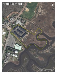
Category: Candidate Restoration/Preservation Site
Location: Located adjacent to the Secaucus High School, Secaucus Tract, and Mill Creek Marsh sites in Secaucus, Hudson County.
Latitude/Longitude: 40.80004/-74.04621
Current Land Use: Tidal marsh
Size: 8 acres
Current Ownership: Louise G. Petrillo
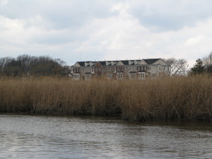
Site Description: The Petrillo Tract includes a lowland marsh area and upland areas. It appears that runoff from residential streets flows into the property. A drainage ditch on the western border prevents runoff from an adjacent parking lot from reaching the upland areas, but it is likely that this runoff reaches the low-lying marsh area. The current conceptual restoration plans includes increasing tidal flow and exchange, restoring intertidal wetlands, reintroducing native wet land species, and restoring upland grassland habitat. A 43-unit town home development was constructed on the upland 3.3 acre portion of this site between 2008 and 2010.
Existing Site-Specific Data Inventory
A. Survey, Maps, and GIS
HMD regional data exists inclusive of this site.
B. Real Estate/Ownership
Owned by Louis G. Petrillo
C. Site History & Land Use
No data obtained.
D. Biological Studies – Fauna
No data obtained.
E. Biological Studies – General Environmental
A variety of data was collected from baseline, habitat, vegetation studies etc. conducted in 1986 and 1990.
F. Geotechnical
No data obtained.
G. Hydraulics and Hydrology
No data obtained.
H. Water and Sediments
No data obtained.
I. Historical/Cultural Resources
No data obtained.
J. Restoration/Remediation Design Plans
Conceptual restoration plan developed in 1986.
Site Reports
Site #25 – Petrillo Tract
Category: Candidate Restoration/Preservation Site
Location: Located adjacent to the Secaucus High School, Secaucus Tract, and Mill Creek Marsh sites in Secaucus, Hudson County.
Latitude/Longitude: 40.80004 / -74.04621
Current Land Use: Tidal marsh
Size: 8 acres
Current Ownership: Louise G. Petrillo
Site Description: The Petrillo Tract includes a lowland marsh area and upland areas. It appears that runoff from residential streets flows into the property. A drainage ditch on the western border prevents runoff from an adjacent parking lot from reaching the upland areas; however, the topography suggests that this runoff reaches the low-lying marsh area. The current conceptual restoration plans includes increasing tidal flow and exchange, restoring intertidal wetlands, reintroducing native wetland species, and restoring upland grassland habitat. A 43-unit town home development was constructed on the upland 3.3 acre portion of this site between 2008 and 2010.
Existing Site Specific Data Inventory
* – Report repeated under multiple data categories and/or sites.
A. Survey, Maps, and GIS
Relevant survey, mapping, and GIS data for the Meadowlands can be found in the Meadowlands-wide site report under data category A.
B. Real Estate/Ownership
Petrillo Tract is owned by Louise G. Petrillo.
C. Site History & Land Use
No data obtained.
D. Biological Studies – Fauna
No data obtained.
E. Biological Studies – General Environmental
1. *TAMS Consultants, Inc. Comprehensive Baseline Studies, IR-2 and Off-Site Mitigation Areas/Evaluation of the Harmon Meadow Western Brackish Marsh Mitigation Area. June 1990. [2] Baseline studies were initiated in 1986 to provide Hartz Mountain Industries with planning information about three proposed mitigation sites – IR-2 onsite mitigation (now known as Western Brackish Marsh), Anderson Creek, and South Secaucus (also known as Riverbend Wetlands Preserve) – by documenting existing ecological conditions of the sites and the Hackensack River in their vicinity for a year-long period.
2. *TAMS Consultants, Inc. Habitat Evaluation Procedure (HEP): IR-2 Site and Off-Site Mitigation Areas: Evaluation of the Villages at Mill Creek Mitigation Program. October 1990. [2] The HEP was used to quantify the habitat value of the proposed IR-2 site (now the Mill Creek Wetland Mitigation Site) and mitigation area (now Western Brackish Marsh), as well as two potential offsite wetland mitigation sites – Anderson Creek Marsh and South Secaucus (also known as Riverbend Wetlands Preserve).
3. *TAMS Consultants, Inc. Technical Report on Vegetation Mapping for IR-2, Anderson Creek Marsh, and South Secaucus Wetland Sites. December 1990. [2]Presents vegetation mapping with supporting data for the IR-2 site (now the Mill Creek Wetland Mitigation Site), its potential onsite mitigation area (now Western Brackish Marsh), and potential offsite mitigation areas – Anderson Creek Marsh and South Secaucus (now known as Riverbend Wetlands Preserve).
4. *TAMS Consultants, Inc. The Villages at Mill Creek (IR-2) Brackish Wetland Mitigation Concept. May 1986. [2] Quantifies the net impact of filling 97.41 acres of USACE-regulated wetlands and enhancing 91.98 acres for the construction of the proposed Villages at Mill Creek was quantified.
5. *TAMS Consultants, Inc. The Villages at Mill Creek (IR-2) Wetland Evaluation Technique (WET) Assessment (Draft). February 1990. [2]A WET functional wetlands value assessment was undertaken in response to a condition of the USACE draft permit for this project. This WET assessment evaluated existing and future conditions at the IR-2 site (now the Mill Creek Wetland Mitigation Site), as well as the potential mitigation sites – Anderson Creek Marsh and South Secaucus (also known as Riverbend Wetlands Preserve). Social significance and functional effectiveness/opportunity of wetlands were evaluated.
F. Geotechnical
No data obtained.
G. Hydraulics and Hydrology
No data obtained.
H. Water and Sediments
No data obtained.
I. Historical/Cultural Resources
No data obtained.
J. Restoration/Remediation Design Plans
6. *TAMS Consultants, Inc. The Villages at Mill Creek (IR-2) Brackish Wetland Mitigation Concept. May 1986. [2] Quantifies the net impact of filling 97.41 acres of USACE-regulated wetlands and enhancing 91.98 acres for the construction of the proposed Villages at Mill Creek.
K. Bibliographic Updates
Site #25: Petrillo Tract


