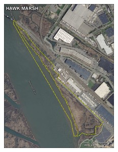
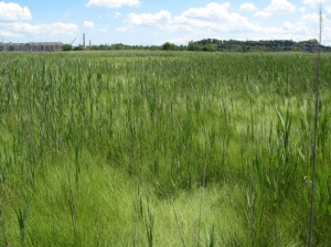
Category: Candidate Restoration/Preservation Site
Location: Along the eastern bank of the Hackensack River, south of the New Jersey Transit Main Line in Secaucus, Hudson County.
Latitude/Longitude: 40.77011/-74.08648
Current Land Use: Tidal Marsh
Size: 38 acres
Current Ownership: NJMC
Site Description: The Hawk Marsh contains some of the last remaining patches of high salt marsh in the Meadowlands, which are surrounded by and being invaded by common reed (Phragmites australis). The northern portion of the site contains some wooded uplands surrounded by common reed marsh.
Existing Site-Specific Data Inventory
A. Survey, Maps, and GIS
HMD regional data exists inclusive of this site.
B. Real Estate/Ownership
Owned by NJMC. Acquisition data available from NJMC.
C. Site History & Land Use
No data obtained.
D. Biological Studies – Fauna
No data obtained.
E. Biological Studies – General Environmental
A vegetation inventory and vegetation mapping of the Hawk marsh was completed in 2010.
F. Geotechnical
No data obtained.
G. Hydraulics and Hydrology
No data obtained.
H. Water and Sediments
No data obtained.
I. Historical/Cultural Resources
No data obtained.
J. Restoration/Remediation Design Plans
The Hawk site was considered for off-site mitigation for the Allied Junction rail transfer station project in the 1990’s. At that time the site was known as “Newman’s Landing”.
Site Reports
Site A – Hawk Marsh
Category: Candidate Restoration/Preservation Site
Location: Along the eastern bank of the Hackensack River, south of the New Jersey Transit Main Line in Secaucus, Hudson County.
Latitude/Longitude: 40.77011/-74.08648
Current Land Use: Tidal marsh
Size: 38 acres
Current Ownership: NJMC
Site Description: The Hawk Marsh contains some of the last remaining patches of high salt marsh in the Meadowlands, which are surrounded by and being invaded by common reed (Phragmites australis). The northern portion of the site contains some wooded uplands surrounded by common reed marsh.
Existing Site Specific Data Inventory
* – Report repeated under multiple data categories and/or sites.
A. Survey, Maps, and GIS
Relevant survey, mapping, and GIS data for the Meadowlands can be found in the Meadowlands-wide site report under data category A.
B. Real Estate/Ownership
C. Site History & Land Use
No data obtained.
D. Biological Studies – Fauna
No data obtained.
E. Biological Studies – General Environmental
Hansen, J., G. Bennett-Meany, and D. Smith. 2010. Vegetation Inventory – 2010. Hawk Property, Secaucus, N.J. Vegetation inventory and mapping of the Hawk property in 2010.
F. Geotechnical
No data obtained.
G. Hydraulics and Hydrology
No data obtained.
H. Water and Sediments
No data obtained.
I. Historical/Cultural Resources
No data obtained.
J. Restoration/Remediation Design Plans
No data obtained.
K. Bibliographic Updates


