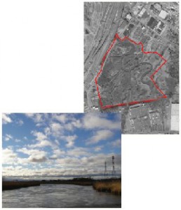
Category: Candidate Restoration/Preservation Site 
Location: North of Bellman’s Creek and east of the Eastern Spur of the New Jersey Turnpike in the Town of Ridgefield, Bergen County, New Jersey.
Latitude/Longitude: 40.83189/-74.01829
Current Land Use: Tidal marsh
Size: 62 acres
Current Ownership: PSEG
Site Description: Bellman’s Creek marsh is dominated by common reed (Phragmites australis) and interspersed with pockets of wooded uplands and mudflats. Portions of the site are used for utility purposes, including a berm running through the site from the northeast to the southwest.
Existing Site-Specific Data Inventory
A. Survey, Maps, and GIS
HMD regional data exists inclusive of this site.
B. Real Estate/Ownership
Owned by PSEG.
C. Site History & Land Use
No data obtained.
D. Biological Studies – Fauna
No data obtained.
E. Biological Studies – General Environmental
Fish sampling study conducted in 1980.
F. Geotechnical
No data obtained.
G. Hydraulics and Hydrology
No data obtained.
H. Water and Sediments
Water quality data was collected in 1980.
I. Historical/Cultural Resources
No data obtained.
J. Restoration/Remediation Design Plans
No data obtained.
Site Reports
Site #13 – Bellman’s Creek Marsh
Category: Candidate Restoration/Preservation Site
Location: North of Bellman’s Creek and east of the Eastern Spur of the New Jersey Turnpike in the Town of Ridgefield, Bergen County, New Jersey.
Latitude/Longitude: 40.83189 / -74.01829
Current Land Use: Tidal marsh
Size: 62 acres
Current Ownership: PSEG
Site Description: Bellman’s Creek marsh is dominated by common reed (Phragmites australis) and interspersed with pockets of wooded uplands and mudflats. Portions of the site are used for utility purposes, including a berm running through the site from the northeast to the southwest.
Existing Site Specific Data Inventory
* – Report repeated under multiple data categories and/or sites.
A. Survey, Maps, and GIS
Relevant survey, mapping, and GIS data for the Meadowlands can be found in the Meadowlands-wide site report under data category A.
B. Real Estate/Ownership
Bellman’s Creek Marsh is owned by PSEG.
C. Site History & Land Use
No data obtained.
D. Biological Studies – Fauna
No data obtained.
E. Biological Studies – General Environmental
1. *Anonymous. Biological Water Quality and Field Sampling Survey of the Hackensack Meadowlands. HMDC. 1980. [1a]Water samples from 11 sites were collected on a single day, measuring temperature, salinity, dissolved oxygen, and suspended solids. The biological portion of the study is negligible, as four fish sampling nets were set in Berry’s Creek Canal and Sawmill Creek, but only one killifish was caught.
F. Geotechnical
No data obtained.
G. Hydraulics and Hydrology
No data obtained.
H. Water and Sediments
2. *Anonymous. Biological Water Quality and Field Sampling Survey of the Hackensack Meadowlands. HMDC. 1980. [1a]Water samples from 11 sites were collected on a single day, measuring temperature, salinity, dissolved oxygen, and suspended solids. The biological portion of the study is negligible, as four fish sampling nets were set in Berry’s Creek Canal and Sawmill Creek, but only one killifish was caught.
I. Historical/Cultural Resources
No data obtained.
J. Restoration/Remediation Design Plans
No data obtained.
K. Bibliographic Updates
Site #13: Bellman’s Creek Marsh
