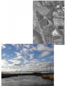
Category: Waterbodies & Other Wetlands
Location: Located in the northeast corner of the HMD, running along/through Bellman’s Creek Marsh, Skeetkill Creek Marsh, and Meadowlark Marsh. The creek begins in Ridgefield and then runs along the border of Ridgefield and North Bergen out to the Hackensack River, in Bergen and Hudson Counties.
Current Land Use: Open Water
Site Description: Bellman’s Creek is tidally influenced. Its banks are primarily mudflats and common reed (Phragmites australis) dominated marsh. The creek flows under the New Jersey Turnpike – Eastern Spur, and through culverts under Westside Avenue. Some flooding of the areas around Bellman’s Creek is common during storm events.
Existing Site-Specific Data Inventory
A. Survey, Maps, and GIS
HMD data exists inclusive of this site.
B. Real Estate/Ownership
N/A
C. Site History & Land Use
Land use information collected for a 1993 wetland delineation of a nearby site.
D. Biological Studies – Fauna
No data obtained.
E. Biological Studies – General Environmental
No data obtained.
F. Geotechnical
Geoarchaeological overview completed in 1985 and baseline data collected in 1993 for a zoning permit.
G. Hydraulics and Hydrology
No data obtained.
H. Water and Sediments
Baseline data collected in the creek for a natural resources inventory in 1971.
I. Historical/Cultural Resources
Geoarchaeological overview completed in 1985.
J. Restoration/Remediation Design Plans
No data obtained.
Site Reports
Site #31 – Bellman’s Creek
Category: Waterbodies & Other Wetlands
Location: Located in the northeast corner of the HMD, running along/through Bellman’s Creek Marsh, Skeetkill Creek Marsh, and Meadowlark Marsh. The creek begins in Ridgefield and then runs along the border of Ridgefield and North Bergen out to the Hackensack River, in Bergen and Hudson Counties.
Current Land Use: Open Water
Site Description: Bellman’s Creek is tidally influenced. Its banks are primarily mudflats and common reed (Phragmites australis) dominated marsh. The creek flows under the New Jersey Turnpike – Eastern Spur, and through culverts under Westside Avenue. Some flooding of the areas around Bellman’s Creek is common during storm events.
Existing Site Specific Data Inventory
* – Report repeated under multiple data categories and/or sites.
A. Survey, Maps, and GIS
Relevant survey, mapping, and GIS data for the Meadowlands can be found in the Meadowlands-wide site report under data category A.
B. Real Estate/Ownership
Not applicable.
C. Site History & Land Use
1. *Louis Berger & Associates, Inc. Wetland Delineation Report. 1993. [1a] Wetland delineation report performed for Lots 1 through 46, Block 137 in Carlstadt, owned by Transcontinental Gas Pipe Line Corporations. Existing wetland documentation/reports evaluated included: 1) 1976 NWI Map; 2) 1989 USEPA Wetland HMDC Assessment Map; 3) 1986 New Jersey Turnpike Technical Study Volume II: Biological Resources; 4) 1989 NRCS Bergen County Soil Survey; 5) 1985 HMDC Aerial Photograph; and 6) 1990 Vicinity Map (topographic map).
D. Biological Studies – Fauna
No data obtained.
E. Biological Studies – General Environmental
No data obtained.
F. Geotechnical
2. *PSE&G Company. Application for the Zoning Certificate for the 12″ Natural Gas Distribution Main. 1993. [1a] Includes the application form and checklist for compliance with environmental performance standards. PSEG (formerly PSE&G) proposed the installation of a 12-inch gas main between the existing PSEG M&R station and the Lowe Paper cogeneration facility in Ridgefield. The use of a horizontal drilling method near the waterway and wetland areas was proposed to reduce environmental impacts. A wetland delineation map is provided.
3. *Schulderein, J. Geoarchaeological Overview of Bellman’s Creek, Hackensack Meadowlands, New Jersey. H-BLRT 1B Appendix (Pages 198 – 219). 1995. [1a]An appendix in a report entitled Jersey City to the Vince Lombardi Park-Ride, Archeological Testing for the Hudson-Bergen Light Rail System prepared by Joan H. Geismar. Undertaken to identify depositional contexts and buried archeological site potential in the vicinity of borehole NA-04 near the confluence of the Hackensack River and the southeast bank of Bellman’s Creek. Discusses other paleoecological research performed in other parts of the Meadowlands.
G. Hydraulics and Hydrology
No data obtained.
H. Water and Sediments
4. *Mattson, C., G. Potera, & M.E. Saks. Water Quality in a Disordered Ecosystem: A Report on the Water Quality Monitoring Study Performed in the Hackensack Meadowlands between June and September 1971. 1971. [1a] Part of a natural resource inventory on which to base future land use decisions and against which to make future comparisons. Chemistry and water quality were measured at 11 sites, including Berry’s Creek, Penhorn Creek, Losen Slote Creek, Bellman’s Creek, Moonachie Creek, Mill Creek, and the Hackensack River.
I. Historical/Cultural Resources
5. *Schulderein, J. Geoarchaeological Overview of Bellman’s Creek, Hackensack Meadowlands, New Jersey. H-BLRT 1B Appendix (Pages 198 – 219). 1995. [1a]An appendix in a report entitled Jersey City to the Vince Lombardi Park-Ride, Archeological Testing for the Hudson-Bergen Light Rail System prepared by Joan H. Geismar. Undertaken to identify depositional contexts and buried archeological site potential in the vicinity of borehole NA-04 near the confluence of the Hackensack River and the southeast bank of Bellman’s Creek. Discusses other paleoecological research performed in other parts of the Meadowlands.
J. Restoration/Remediation Design Plans
No data obtained.
K. Bibliographic Updates
Site #31: Bellman’s Creek
