Due to climate change and restricted tidal flow from sea walls and dikes planned as part of a resilience project, increased emissions of N2O and CH4 may occur. These factors along with the limited amount of fresh water flowing into the estuary from the upper Hackensack would then offset the reduction in radiative forcing currently attributed to carbon sequestration.
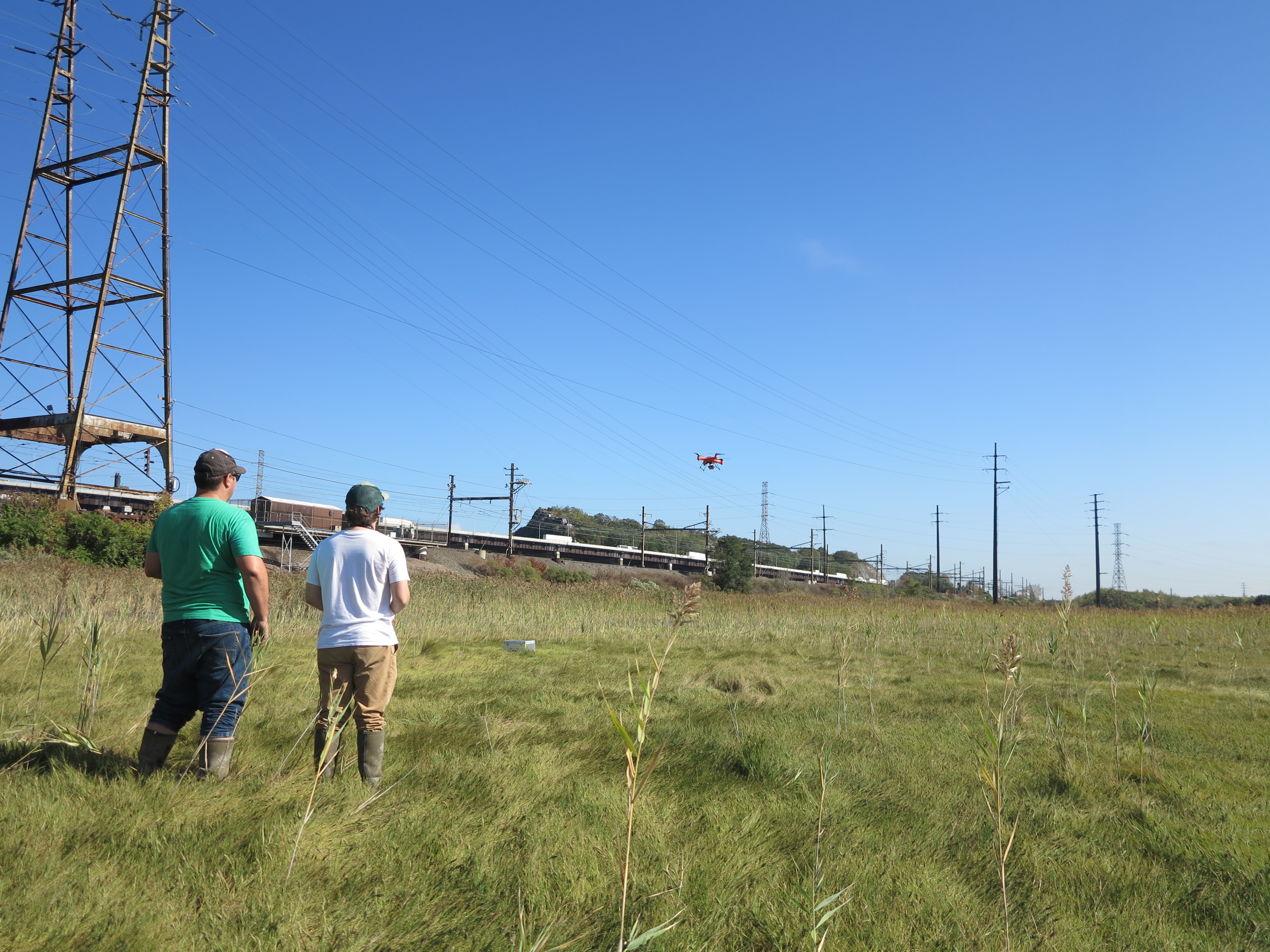
MERI’s gas emission baseline study to baseline the emissions of carbon dioxide, methane and nitrous oxide and assess the carbon sink strength of the Meadowlands ecosystems..
The study will measure the emissions of CH4 and N2O across a salinity gradient and across marshland surface types and it will assess the carbon emissions and sequestration potential of these same surfaces. The CO2 flux between the marsh canopy and the atmosphere will be measured using eddy covariance methods and the emissions of CH4 and N2O will be determined using static flux chambers. In addition, pore water measurements of SO42-, NO3–, NO2–, NH4+, salinity, pH, and total organic carbon (TOC) will be measured from all locations where gas emissions are measured. Tidal influence on CO2 fluxes will be determined by continuous measurements of water elevation near the sampling sites
Outputs from this study will become the basis for developing strategies that will inform future enhancement and mitigation actions on introducing adaptability features into new resilience designs so that marshlands maintain their terrestrial carbon sequestration function and are not offset by emissions of CH4 and N2O as result of more frequent coastal storms and associated sea level rise. Results from this study will also be used for testing future sensitivity and adaptability of marshlands to climate and related global changes.
The Meadowlands Environmental Research Institute has received a Broad Area Airspace Authorization for the Hackensack Meadowlands area. The broad area airspace authorization allows MERI to conduct drone operations in Class D airspace governed by Teterboro Air Traffic Control’s jurisdiction. The authorization covers the growing season from May 03 through September 30, 2018.
In April 2018, Meadowlands Environmental Research Institute (MERI) laboratory finished their annual Proficiency Testing (PT) study. All of the 60 certified parameters, including trace metals, low-level mercury, PCBs, organochlorine pesticides, minerals, simple nutrients, pH and turbidity, have been evaluated and considered as acceptable. MERI laboratory has been recognized as a Laboratory of Excellence for achieving 100% acceptable data in this study which included 1004 participating laboratories. This achievement is a demonstration of the superior quality of the laboratory performance.
Scientists from the Department of Earth and Environmental Science Rutgers University Newark and MERI scientists were trained by German engineers in the use of their new state- of-the- art Nordmeyer GEOTOOL . The Geotool is a precision drilling machine that will be used in near surface geophysical research to develop methods and technology to monitor the movement of contaminates underground and to monitor salt water intrusions into fresh groundwater reservoirs among many others. The Geotool can be configured in three ways: 1.- Soil dynamic probing for geotechnical investigations, 2.- Deep soil and sediment stratigraphic sampling and 3.- Deep hole drilling for wells and sensor deployment .
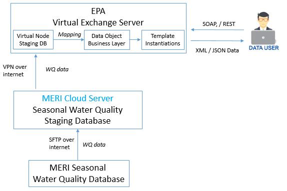
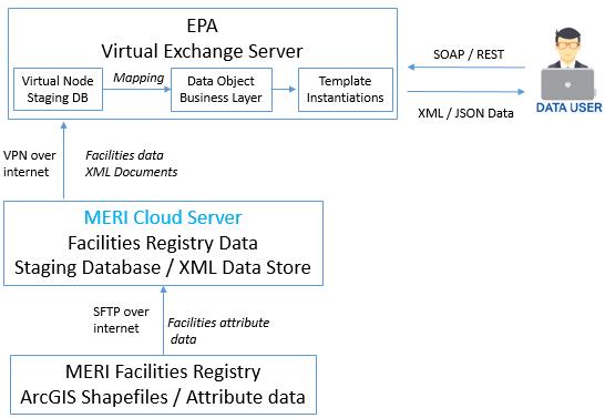
FY2017 National Environmental Information Exchange Network Grant Program
This project will utilize EPA’s current continuous water monitoring exchange framework (WaterML 2.0 and SensorML formats) to share continuous water quality data and its associated metadata. The project will encode continuous air quality sensor data based on the same procedures and framework established for continuous water quality data, as well as configure data flows and test the Extensible Markup Language (XML) schema for sharing discrete seasonal water quality data throughEPA’s WQX system; and, will configure data flows and test existing XML schema to upload Facility Registry data and location via the Virtual ExchangeServices to EPA’s Facility Registry Service.
Using geophysical technologies to delineate and monitor saltwater intrusion within New Jersey coastal aquifers.
A study, funded through a NJWRRI (New Jersey Water Resources Research Institute) research grant, used two geophysical methods, self-potential (SP) and electrical resistivity (ER) imaging to look at saltwater intrusion in Cape May County, NJ. SP measurements were collected in a USGS monitoring well to capture changes in electrical conductivity (as a proxy for salinity) ahead of the occurrence of a salt water intrusion event, marked by increases in conductivity. MERI and Rutgers-Newark associates teamed up on December 22, 2017 to conduct marine ER continuous vertical electrical sounding (CVES) surveys within the Delaware Bay along two creeks. These electrical measurements will be analyzed to determine the transition from freshwater to saltwater within the sediments adjacent to the Bay.
MERI GIS Specialist Brian Wlodawski presented “Environmental and Industrial Site Assessment Using Drones” giving an overview of the capabilities and applications of current drone technology at the Solid Waste Association of North America (SWANA) New Jersey Annual Conference.
I want to thank everyone who participated in Super Storm Sandy five years later. We had over 150 attendees, 28 oral presentations and over 20 posters. With a central theme of Super Storm Sandy five years later; presentations touched on a number of topics including: sediment and contaminate transport, assessing fugitive chemicals and exposure to recovery workers, uncertainty in sea surge forecasts, retreat strategies from coastal areas and effective communication when explaining the weather, among others. The conference provided a forum for the exchange of ideas across disciplines that will help create a consensus on how to make our coastal communities and ecosystems more resilient in the future.
The NJ (Rutgers-Newark) student chapter of the Association of Environmental and Engineering Geologists (AEG) visited River Barge Park Marina and toured the estuaries of the Hackensack River with Francisco Artigas Director of of MERI.. The goal of the chapter is to provide an opportunity for students affiliated with environmental and engineering geology programs to meet with professionals. We promote activism and awareness for issues such as climate change and sustainability with the goal of motivating students of their responsibilities as environmental stewards.We also provide public understanding of the geologic and hydrologic environment and how to correct environmental mistakes.
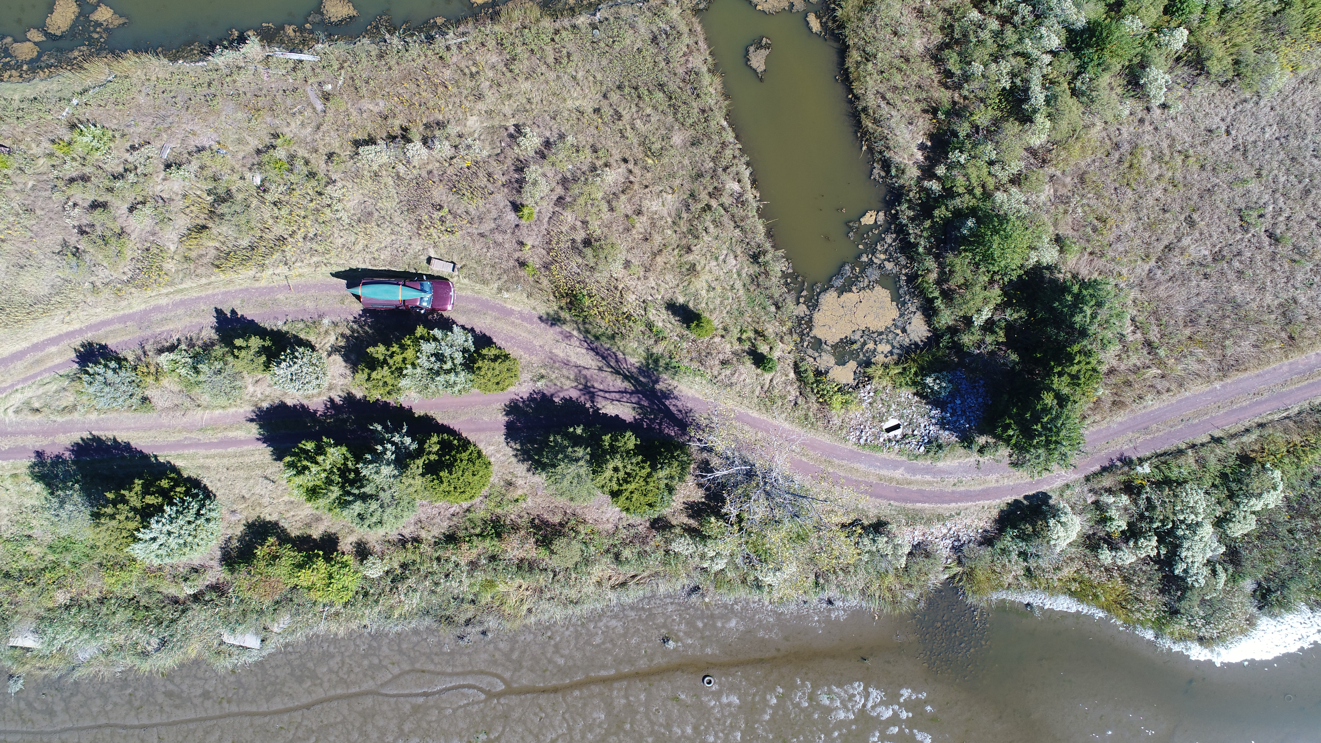
MERI is using drones (small unmanned aircraft systems) to capture high resolution panoramic and ortho imagery. MERI’s fleet of drones create image, 4k video, and 3D modeling products. Drones are used for site assessment, creek and ditch inspections, wetlands surveying, identifying marsh plant communities and invasive species, as well as terrain modeling. MERI has FAA part 107 sUAS certified pilots. For drone project inquiries please contact GIS Specialist Michael Stepowyj. Michael.Stepowyj@rutgers.edu 201-460-4693