Participants: MERI, Natural Resources, Rutgers Newark
Problem:
There have been comprehensive studies and planning documents in the past three decades regarding the wetland enhancement in the Meadowlands. These documents indicate the need to measure the physical and ecological impairments to ecological function and to perform plant biodiversity assessments as a first step towards wetland enhancement. Seven tidal wetland sites totaling one hundred and five hectares (105 Ha) were selected to measure ecological function and impairments, including the nature and extent of invasive species, lack of plant diversity, lack of tidal exchange, and habitat fragmentation.
Objectives:
Create a plan for better wetland enhancement and restoration by identifying quantifiable restoration metrics and gathering strategic data to select sites appropriate for acquisition and wetland enhancement and restoration.
Strategy:
We propose to use a combination of traditional field monitoring techniques along with remote sensing methods and modeling to characterize species diversity, habitat fragmentation, and hydrological restrictions as a way to measure impairments to wetland function.
Activities:
- Measure flora diversity and vegetation cover
- Acquire and classify high resolution hyperspectral images as well as the balloon imageries of the sites
- Acquire Light Detection and Ranging (LiDAR) images of the sites
- Measure hydrologic and hydrodynamic data to characterize hydrological restrictions
- Collect the bathymetry data
- Complete watershed delineation using LiDAR derived Digital Elevation Model (DEM) and water flow model
- Analyze habitat fragmentation
Deliverables:
- A series of maps, tables, and animations describing wetting periods and topography, species diversity, plant assemblages, wetland indicator status for each species, plant rarity scores, and species patchiness
- A high resolution DEM to model and visualize tidal flow at each site
- A master matrix of measured parameters and metrics will include scores on acquisition and enhancement priorities

Secaucus High School Wetland Enhancement Site
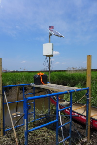
Stage-Velocity Measuring Station
Photo by Dr. Fransisco Artigas
Acknowledgement:
- The project is funded by EPA Grant No. CD-96294800.