NJMC-MERI GIS Team takes Best Overall Map Award at the NJDEP 27th Annual Mapping Contest
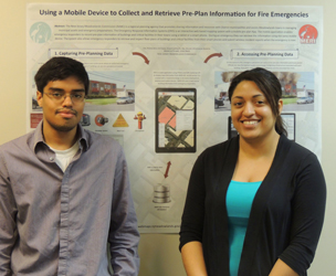
A record 40 maps were entered in the NJDEP’s 27th annual GIS mapping contest held April 10 in Trenton. There were eight categories that accompanied this year’s theme: GIS Keeping New Jersey Safe. The contest winner, “Using a Mobile Device to Collect and Retrieve Pre-Plan Information for Fire Emergencies” was created by Marielis Nunez and Jose Baez and took the BEST OVERALL MAP awarded.
LiDAR Acquisition of the Meadowlands
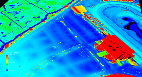
The LiDAR acquisition of the Meadowlands was completed on Friday, April 11, 2014. LiDAR raw files will be processed by the PhotoScience Team, delivering the following products: 1)LAS files of 1st, 2nd and 3rd Returns; 2)DEM created for the Meadowlands region at 1-foot resolution; 3)Contours derived form LiDAR data; 4)Hydro-breaklines
NJMC Flyway Gallery Hosts Exhibit
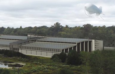
University students’ visions of the conceptual transformation of a former trash transfer facility into an aviation museum are the subject of a new exhibit at the New Jersey Meadowlands Commission’s (NJMC) Flyway Gallery. The show, “NJIT Design Studio,” will be on display from Thursday, March 6, through Friday, April 25. An opening reception is scheduled for Friday, March 7, from 1:30 to 3:30 p.m.
MAP EXHIBITION PROJECT AT THE MEADOWLANDS MUSEUM
- Presented by: Frank Gerard Godlewski
- Location: The Meadowlands Museum, Yereance Berry House
FINDING OUR PLACE IN HISTORY
MAP EXHIBITION PROJECT
OPENING EVENT
Friday, JUNE 28th, 7:30 pm – 9:00pm
Saturday, 10am – 4pm
Location:
The Meadowlands Museum,
Yereance Berry House
91 Crane Avenue, Rutherford, NJ 07021
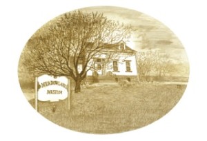
The Meadowlands Museum, preserved in a historic 19th Century Dutch-American farmhouse, within view of the NYC skyline and the Meadowlands Sports Complex, opens the new season with a dynamic public interaction exhibition project focusing on the Museum’s remarkable collection of local maps. The community is welcome to view this special map exhibit highlighting the site of the Yereance-Berry House (now the Meadowlands Museum) from the 1680’s to the present. From these maps we discover that the Museum’s Yerence Berry House was a larger farmhouse on a main road surrounded by fields and that the adjacent Crane Avenue was a brook with ponds that flowed down to Berry’s Creek. See how the area has changed, find the location of your own home and compare how the area has developed over time!
This summer, the museum will be open on Saturdays and the public is invited to learn about the establishment and development of Rutherford as well as the surrounding Meadowlands Communities and even gain interesting facts about our own homes.
The public is welcome on Friday June 28 from 7:30 to 9 PM and on Saturday, June 29, from 10 AM to 1 PM. This re-opening kicks off the Museum’s summer season. During July and August, the Museum will be open on Saturdays from 10:00 am until 4:00 pm.
Information: Frank Gerard Godlewski fellsbridge@gmail.com
Link from the South Bergenite:
“Water level observations during super storm Sandy”
The Meadowlands Environmental Research Institute (MERI), the science branch of the New Jersey Meadowlands Commission (NJMC), released a study on Hurricane Sandy, concluding no specific break was to blame for the historic flooding experienced by local towns, but rather the sheer size of the unprecedented storm surge caused the area to become inundated with water. Dr. Francisco Artigas of MERI explained the agency was in a unique position to study the surge, as a few of the water level sensors installed around the Hackensack River in 2004 survived the storm. The commission’s River Barge Park Marina, located in Carlstadt, and the Moonachie tide gate on the river near Turnpike Exit 18W collected data as the waters rose on Oct. 29.
NJMC meets with Senator Paul Sarlo to discuss Flooding Issues
State Sen. Paul Sarlo, D-Wood-Ridge, met for the first time Monday afternoon with a group of roughly 15 representatives from the Meadowlands Commission, the state Department of Environmental Protection, the mayors of Moonachie and Little Ferry, and local engineers to discuss the Oct. 29 storm and lay out preventative measures. “We talked about some of the incremental steps we can take, measures to protect us from various different storms, but I am not sure whatever we will be able to do would protect us from a surge of that magnitude,” Sarlo said — 9.5 feet of water easily topped the 4- and 5-foot-high berms. “The government cannot keep putting Band-aids on infrastructure. I’m not sure we can be prepared for every storm, but we need to implement measures for 75 or 85 percent of storms.” “There are significant dollars in the federal package that would alleviate some of this flooding,” Sarlo said. “I am going to fight on behalf of the people of the Meadowlands.”
MERI Library Open House
A daylong MERI Library Open House for NJMC Staff was held on December 6, 2012. The highlight of this event was a demonstration and presentation of the new AGent VERSO Library Automation System by the New Jersey Meadowlands Commission Librarian, Tammy Marshall. Features of the new system include Personal Account Access and an integrated Circulation and Interlibrary Loan System. The event was well attended and well received by the NJMC Staff.
ECO SUMMIT 2012
- Presented by: Dr. Francisco Artigas
- Location: Columbus, Ohio
Restoration and monitoring of an urban estuary in northern New Jersey. The Hackensack River estuary in northern New Jersey sits just six miles west of Manhattan Island. It is surrounded by some of the most densely populated and industrialized areas of the nation. In the early 1900s, municipal landfills were established in the estuary and in 1922 a dam reduced the flow of fresh water thus greatly limiting the natural flushing ability of the system. For years, toxic substances seeping from the landfills entered directly into the estuary. Frequent spills from oil storage facilities and oil slicks from illegal dumping were common, and overtaxed sewage treatment plants discharged 115 million gallons per day of minimally treated sewage directly into the nearby creeks and waterways. In the 1930s, residue from nearby chromite ore processing plants was used as foundation material for industrial sites as well as wetland backfill and even scattered into the neighboring urban environment. Records show that between 1929 and 1972 more than 268 tons of mercury-contaminated toxic waste was dumped into creeks that today show some of the highest concentration of mercury in sediments in the world. Coal power plants continue until today to emit greenhouse gases and associated heavy metals into the surrounding air. By the 1970s the estuary was considered destroyed; a highly disturbed and truncated ecosystem where many of the shellfish, crustaceans and finfish had been eliminated. Thirty years later, the estuary is showing signs of improving, and it is seen as a patient that has been under intensive care for the past 30 years. Landfills have been closed, and most of the point sources of pollution have been eliminated as sewage treatment plants have been closed or re-engineered and upgraded. Restoration efforts include replacing contaminated surface sediments with re-engineered clean sediments, removing invasive species, re-grading, and re-establishing native plant communities and tidal flows. Marsh elevation and plant community development over time are monitored using modern remote sensing techniques (e.g. hyperspectral and LiDAR). Plant, benthic invertebrate, fish and bird diversity and density are central to the biodiversity monitoring efforts. Sediment chemistry conditions are monitored to verify that restored areas are not being re-contaminated by tidal waters. The presentation will show how restoration efforts — coupled with biodiversity measurements and continuous air, sediment and water quality monitoring efforts — are helping to return many of the lost ecosystem services. The presentation will also provide reliable baselines to measure progress and lay out the scientific foundation on which to base policy decisions.
Preliminary Study “An overview of nitrate and nitrite concentrations in soil from the Meadowlands".
- Presented by: Erika Baldino
- Location: Meri Conference Room
“Nitrous oxide is the world’s third largest greenhouse gas which, in high concentrations, can negatively affect both plant and animal health. It is released into the atmosphere by a process known as the Nitrogen Cycle. This is a natural process where nitrogen is reduced with hydrogen to yield ammonia, a form of nitrogen commonly used by most living species to synthesize proteins, nucleic acids and other nitrogen containing compounds. The residual nitrogen is then converted into nitrous oxide mostly by bacteria found in both soil and plant roots. This presentation is based on a preliminary study for larger research concerning the ratio of nitrogen ions and nitrous oxide in the marsh ecosystem of the Meadowlands region. Sediment from eight various sites have been sampled twice in a two week period and analyzed for anions, mainly nitrate and nitrite. Two sites with the highest total nitrate + nitrite concentration, one landfill and one naturally occurring wetland, will be selected and sampled repeatedly next year for both nitrous oxide concentrations and soil. The data will be analyzed to explore 1) the impact of varying levels of nitrate concentrations in soil and their relationship to nitrous oxide, 2) how this relationship differs between a landfill site and a man-made wetland, and 3) the seasonal impact on nitrous oxide admission.”
