2013 Abstacts
Real-Time Sensor-Based Superstorm Sandy Surge and Inundation Model for Moonachie, Carlstadt, and Little Ferry: Bergen County, New Jersey.
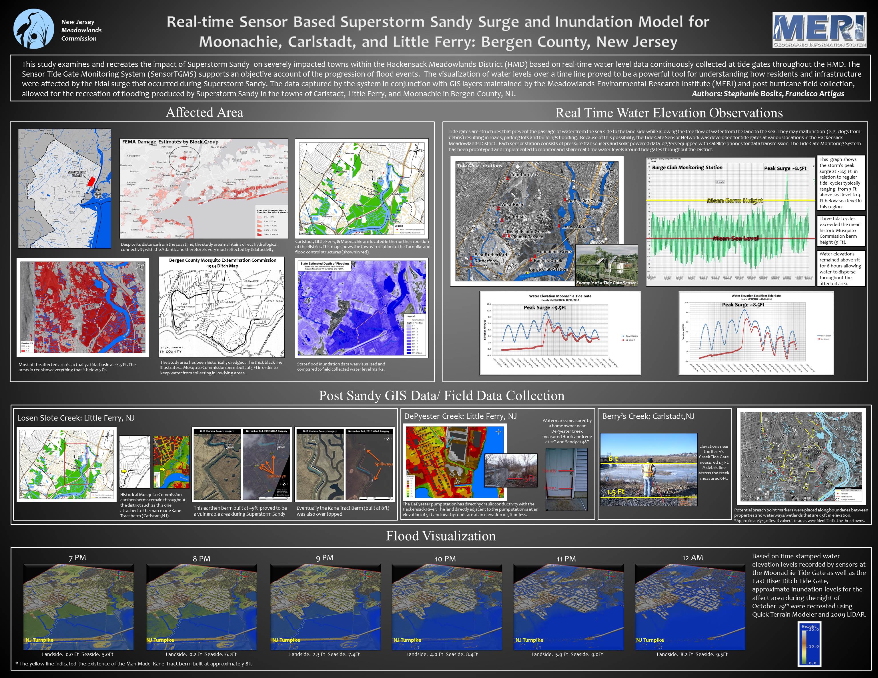
This poster outlines a study conducted by the New Jersey Meadowlands Commission (NJMC) Meadowlands Environmental Research Institute (MERI) examining and recreating the inundation of several towns within the Hackensack Meadowlands District (HMD) that were severely impacted by Superstorm Sandy. Despite the distance of these towns from the coast, they experience direct hydrologic conductivity with the Atlantic Ocean via the Hackensack River and a number of other tributaries. Much of this area is a low lying tidal basin that has been historically dredged by the New Jersey Mosquito Commission. This study allowed for a better understanding of the geography of the area as well as the creation of a flood inundation model. Real-time water elevation data collected throughout the storm allowed us to create a timeline of inundation and to pinpoint the height and time of the peak surge in several locations. This data in conjunction with GIS data layers maintained by MERI as well as post Sandy field collection of watermarks and precise elevation readings allowed for a deeper understanding of how the inundation occurred.
Mapping Earthen Berms in the Meadowlands

In the Meadowlands District a berm is a raised ridge of earth that results from excavating drainage ditches as a mosquito control strategy to prevent standing water in low-lying areas. Earthen berms also prevent waters from high tides from reaching and ponding in the low lying meadows. Between 1913 and the late 1970’s hundreds of miles of ditches were dug in the vicinity of the towns of Carlstadt, Little Ferry and Moonachie and the average berm height was about 5 feet above sea level. Until super storm Sandy, this berm system protected the residential and industrial areas of these towns from the highest of the high tides. Sandy’s sea surge measured 8.5 to 9.5 feet and overtopped all existing earthen berms. Using LIDAR, Hyperspectral Remote Sensing and digital terrain models the Meadowlands Environmental Research Institute (MERI)-Geographical Information Systems (GIS) team has embarked in a project to precisely map the location and the elevation of all legacy berms in these low lying towns. Specifically, identify “soft edges”, i.e. berms that are less than 5 feet in elevation, within the more than 100 miles of earthen berms and locate areas and neighborhoods most at risk from sea surge flooding.