Participants: Rutgers University Newark and MERI
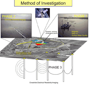
Scientists from Rutgers University and MERI are using state-of-the-art-high-resolution geophysical imaging technologies to study the shallow waters of Meadowlands District wetlands. Methods developed in New Jersey will ultimately be used to study wetlands throughout the world. In Kearney Marsh, researchers used a small paddle boat carrying a variety of geophysical sensors to collect extensive water quality data. Terrain conductivity, magnetic gradiometry and electrical resistivity imaging (ERI) technologies all provided data which was then integrated within a Geographical Information System (GIS) database. The database allowed scientists to get a “full picture” of the waters above and below the ground. In one study using the new technologies, researchers looked specifically at sources of pollution entering, or potentially entering, the marsh. Previous direct sampling of water and sediment at spot locations had pointed to the nearby Keegan Landfill as a possible source of contamination in Kearney Marsh.
Figure 1: Overview of the technological concept incorporated into a study of a wetland system, the concept includes three main phases: (a): rapid reconnaissance geophysical surveys from shallow water boats including magnetic, EM31 and surface water quality survey; (b) electrical resistivity imaging (ERI) monitoring; (c) cross hole ERI monitoring.
The new data confirmed some earlier findings and suggested others require further examination. For example, the study confirmed evidence of a leachate plume (an area of contamination) in the groundwater near the southern portion of landfill, but it also suggested that the marsh’s surface water did not include a leachate plume as had previously been believed.
